|
106AA.
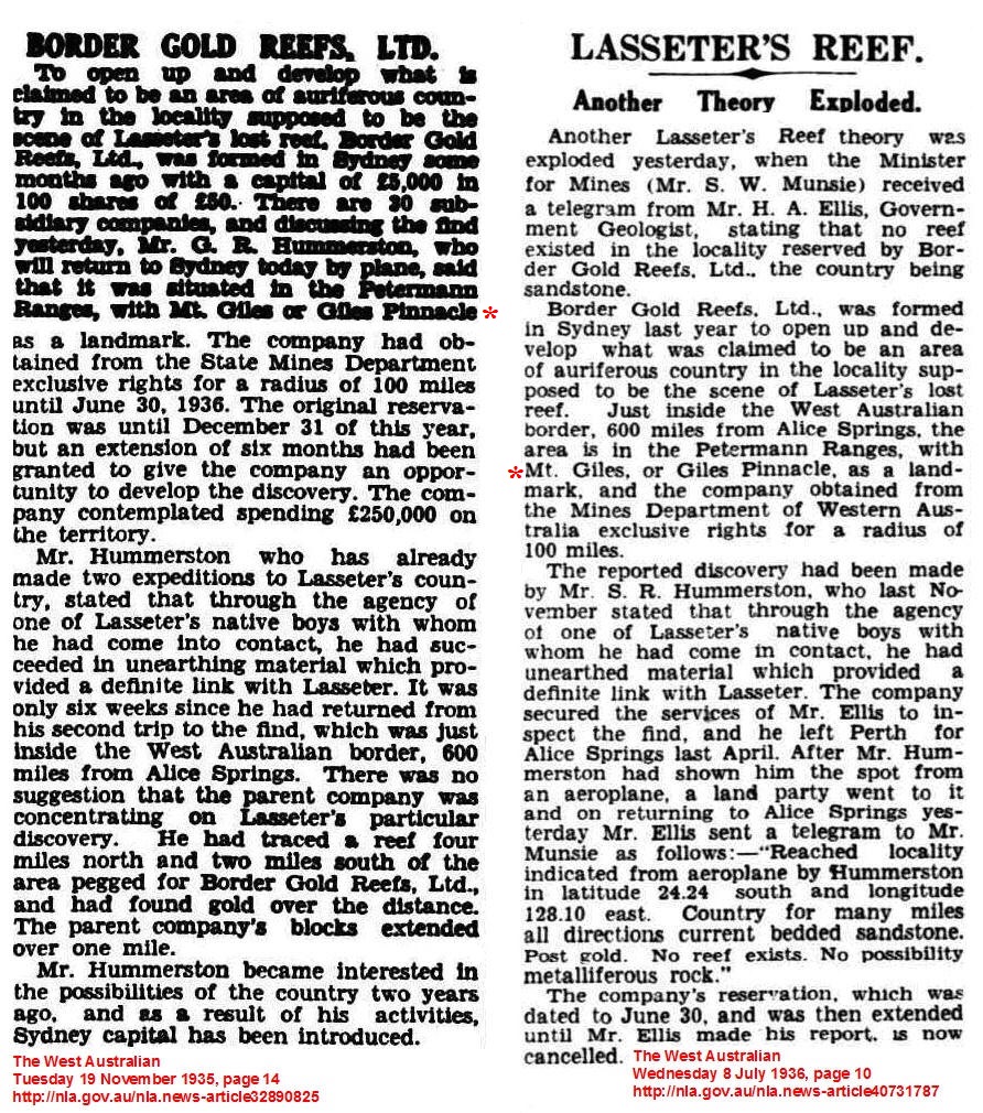
GILL PINNACLE. |
|||
|
"The
natives at the camp told Buck of another water at the foot of a
conspicuous dome shaped hill."
The conspicuous
dome shaped hill that Talbot referred to was Gill Pinnacle, an
important landmark at the eastern end of the
Schwerin Mural Crescent; it points the way to one of the Centre's more reliable waterholes,
Gordon Spring, which is located several hundred meters to the north.
The feature is often misnamed Giles Pinnacle, as in Philip Taylor's
letter of instruction to Bob Buck, detailing the search for Harold
Lasseter or his reef, "You
will at this point cross the border into W. A. and onto Giles
Pinnacle".
Buck did not cross the border on this journey, he buried the
unfortunate prospector at Winters Glen, about
70 miles to the south east,
on 28/03/31. H. W. B. Talbot,
who was the geologist on the Second C.A.G.E. Expedition, under the
leadership of Buck, arrived at Gordon Spring on 21/10/31, he left a
thought provoking record of events that took place there. Gill Pinnacle is an
outstanding landmark, first sighted by Ernest Giles and his
companion, W. H. Tietkens from Weld Pass on 10/03/1874, "From
hence we had a good view of the country farther east. A curved line
of abrupt-faced hills traversed the northern horizon; they had a
peculiar and wall-like appearance, and seemed to end at a
singular-looking pinnacle thirty-four or five miles away, and lying
nearly east. This abrupt-faced range swept round in a half circle,
northwards, and thence to the pinnacle."
From Weld Pass to the
pinnacle was a difficult traverse over very rough ground and through
dense mulga and occasionally harried by the Aboriginals who set fire
to the spinifex. The following morning the explorers were in the
vicinity of the pinnacle, cutting their way through thick scrub when
they emerged on the banks of a creek and always searching for water
they travelled upstream and "soon
saw some green rushes in the bed. A little further up we saw more,
brighter and greener, and amongst them a fine little pond of water.
Farther up, the rocks rose in walls, and underneath them we found a
splendid basin of overflowing water, which filled several smaller
ones below. We could hear the sound of splashing and rushing waters,
but could not see from whence those sounds proceeded. This was such
an excellent place that we decided to remain for the rest of the
day."
On the 21st of October 1931, the Second C.A.G.E. Expedition arrived
at a waterhole near Mount Gibraltar, according to Talbot's diary,
Buck learnt from the Aboriginals camped at the waterhole that there
was rockhole about seven miles west,
"at
the foot of a conspicuous dome shaped hill ~ it was near the rock
hole that Lassetter had pegged some leases."
Rather than follow up this clue immediately Buck chose to remain at
Mount Gibraltar with Brandon-Cremer and Johnson Breaden filming
Aboriginal life, he sent the rest of the expedition ahead to locate
the rockhole and Lasseter's claim pegs, "We reached the rock hole at 2.15 but then it was found that none
of the natives knew anything about the whereabouts or Lassetter's
pegs". Talbot
finished the days entry with some terse comments on the mettle of
his travelling companions, "Blatchford,
Larry and I watered the camels at the rockhole. It was a long job as
a road had to be made for the camels and a trench had to be cut to
allow the water to get to where the camels could reach it. None of
the others offered to assist at the job. They sat in camp. Green of
course was cook." Talbot noted the location of Camp XVII as 24°54'12" S. and Gordon Spring, known locally as Kugindirri or
Kutjuntarri, was 12 chains to the north. The following
morning Talbot took a round of bearings from the summit of Gill
Pinnacle and returned to camp at lunchtime, just as Buck and his
party arrived from the east, Talbot immediately confronted Buck with
a navigational problem, "I
explained to Buck that unless I got a time signal I could not be
sure of my longitude",
(a fundamental of navigation that Lasseter failed to understand)
some unnecessary discussion took place before Buck authorised
Fulton, the Expeditions radio operator, to contact Mr. Les Bridge
who would arrange for a time signal to be broadcast, it then came to
light that Fulton did not have the right equipment to receive time
signals. Talbot let the matter rest, he had already deduced from
past incidents that the search for Lasseter's Reef was not the
Expeditions main objective. Talbot and Blatchford would be
incommunicado until they returned to Hermannsburg. Buck had returned
from Mount Gibraltar with an Aboriginal who knew where Lasseter had
prospected, "and
after lunch we went and inspected the place. We could see no signs
of workings but the native stated he had been working on a
watercourse and had put in a peg which had since been washed out. A
reef ran a short distance along the side of the creek but knapping
failed to show any gold". It's quite possible that Lasseter did visit Gordon Spring, he
left ample evidence of his travels further west, and the often
quoted lines from one of his last letters, "I photographed the datum post on
the quartz blow. The post is sticking in a waterhole and the photo
faces north",
is vague enough to
include Gordon Spring and perhaps two or three other waterholes
between the Hull River and Lake Christopher. Lasseter added that,
"the blacks have a sacred place nearby and will pull the peg up for
sure", not
surprisingly, Giles left a very detailed and lurid description of
the Aboriginal ceremonial ground that he found at Gordon Spring,
describing one large bare rock in the creek bed as a kind of
teocallis and imagined the gory rites that took place there. At this point in
the journey it was obvious that the Second Expedition was not
following any invisible ink directions written by Lasseter, but were
more or less tracking him west at the whim and guidance of any
Aboriginals who had witnessed his movements, the expedition relied
on local knowledge, Taylors letter and like Lasseter, Giles maps.
And Giles should have the last word, to clarify the nomenclature.
"There is very poor grazing ground round this water. It is only
valuable as a wayside inn, or out. I called the singular feature
which points out this water to the wanderer in these western wilds,
Gill's Pinnacle, after my brother-in-law, and the water, Gordon's
Springs, after his son. In the middle of the night, rumblings of
thunder were heard, and lightnings illuminated the glen. When we
were starting on the following morning, some aborigines made their
appearance, and vented their delight at our appearance here by the
emission of several howls, yells, gesticulations, and indecent
actions, and, to hem us in with a circle of fire, to frighten us
out, or roast us to death, they set fire to the triodia all round.
We rode through the flames, and away.(12/03/1874).
© R.Ross. 1999-2010 |