|
273. THREE SISTERS The. |
|||
| "They looked like three women in sun-bonnets talking to one another". | |||
| Lasseter to Coote, Illbilla. 03/09/30. COOTE, E. H. Hell's Airport. 2nd Edition, pg.158. | |||
|
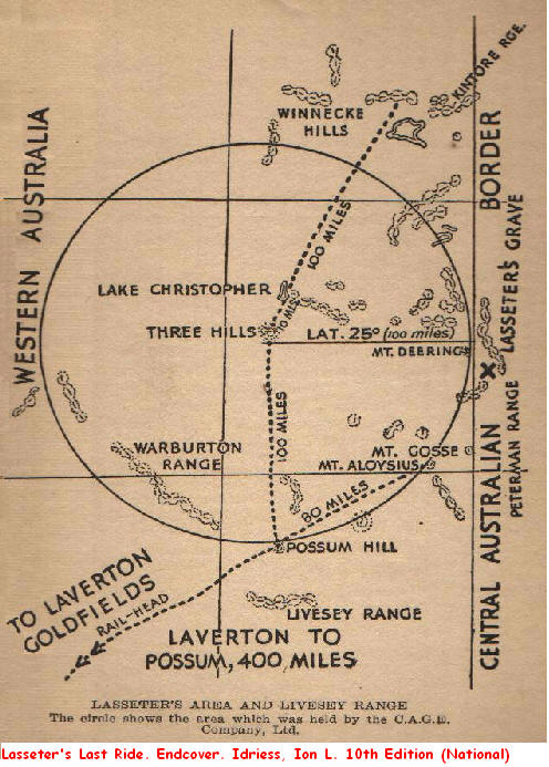
There are no references or directions in Lasseter's hand that give any bearings to the location of his gold reef, although many others have written with authority on the landmarks that indicate the position of the bonanza. One of the first and most quoted is Errol Coote in Hell's Airport where he records in detail a conversation between himself and Lasseter at Illbilla on the 3rd of September 1930.
Coote went on to say that at least Lasseter's directions and description of the landmarks were something to go on, but significantly adds, "I felt that I had not got the right cue. He (Lasseter) had denied, when in Sydney, that the lake was Christopher". Coote concluded that Lasseter's denial regarding Lake Christopher may have been done, "to put us off the scent". Thus leaving Coote in a very similar position to Fred Blakeley when he confronted Lasseter with his impossible story on the summit of Mount Marjorie (Mount Liesler) a little over a week earlier. While Coote was recuperating in Alice Springs after the crash of the Golden Quest, Fred Colson paid a visit with some exciting news from a friend in Kalgoorlie, according to Colson's friend, a part Aboriginal had recently arrived in Laverton with some exceedingly rich gold samples, "They were almost pure gold", these specimens allegedly came from an area south east of the Warburton Ranges, "near a point called the Three Sisters". Colson then showed Coote a well worn map of the country between the Warburton and Musgrave ranges and directly north of the Blyth Range were three hills known as the Three Sisters. Coote took Colson's letter and map as confirmation of Lasseter's claims but did wonder what the expedition was doing so far north at Illbilla. At about this time Fred Blakeley was also having his doubts about the location of the expeditions base camp. Blakeley and Lasseter climbed to the summit of Mount Liesler on 24/08/30 so that Lasseter could get his bearings, after some inexpert fiddling with the sextant Lasseter announced that the expedition was 150 miles too far north, according to Blakeley's calculations that meant the expedition should be in the Petermann Ranges, country already well prospected and not a skerrick of gold found. It also confirmed in Blakeley's mind that Lasseter was a fraud and he bluntly accused him of deception. Thus exposed, Lasseter produced a map and said, "I did not intend to give you this information yet, but you see these hills marked the Three Sisters? Well, that's where I want to go for I am sure I can relocate myself once I get there". Blakeley remained unconvinced. Later in 'Dream Millions' Blakeley writes that he had possession of Lasseter's map for three weeks and notes that he had marked the location of a small lake and the Three Sisters and, "between that lake and the Three Sisters was supposed to be the position of the non-existent reef". Blakeley does not name the lake, presumably it is the same lakelet that Coote mentions in his record of discussion with Lasseter, and it remains quite unclear as to whether that lakelet is Lake Christopher or some other adjacent salt or clay pan. It is of course a moot point. Ion Idriess in Lasseter's Last Ride does not mention a specifically named landmark known as the Three Sisters, but on the inside rear cover of his book he shows a generalised map centred on Lake Christopher with three hills about ten miles south west of the lake, these hills are prominently named and the reader is meant to assume that these are the Three Sisters mentioned by Coote and Blakeley. According to Idriess these hills are the centre of the 100 mile radius prospecting claim taken out by the Central Australian Gold Exploration Company in 1932. There is no record to date that C.A.G.E. ever lodged such a claim with the Western Australian Mines Department, although in October 1932, the company did apply for a circular protection lease of fifteen miles radius approximately fifteen miles west of Lasseter's Cave. This application was denied by the authorities who firmly pointed out that C.A.G.E was no longer welcome in the South West Aboriginal Reserve. And so to the official maps covering the 'Area of Interest', do the 'three hills' of Idriess and the Three Sisters from Blakeley and Coote exist? After all they are one of the few consistent landmarks indicating the location of Lasseter's Reef, although Lasseter never mentions them in any of his writings and notably absent from his diary and last letters. One would have expected these landmarks, once rediscovered by Lasseter, to figure prominently in these documents. As he writes in page 80 of his Diary, "I had to go right out to Lake Christopher which is 100 miles across the W. A. border in order to get my bearings then I was able to go direct to the reef". Perhaps the Three Sisters, supposedly lying at the end of the reef, are not such an a critical landmark after all. There are over 40 locations in Australia named the Three Sisters, perhaps the most famous being located in the Blue Mountains of New South Wales, but there are none near Lake Christopher in Western Australia. It does come as a surprise however, to find Idriess's 'three hills' named and located approximately fifteen miles south west of Lake Christopher on the Cobb, 1:250,000 scale geological map and conveniently close to the Gunbarrel Highway. Perhaps Lasseter's enormous gold reef is south east of these three hills. Of course the Three Sisters and the Three Hills are a fabrication and it didn't originate with Lasseter, it could have been Idriess who admits that later editions of Lasseter's Last Ride included additional information from the second C.A.G.E expedition, and much of Idriess's best seller is based on interviews with Blakeley who was one of the first to hear Lasseter's story when at Mount Marjorie. The culprit may have been Coote, desperate to continue the search for the reef to protect his vested interests and disintegrating reputation. Much would depend on what Idriess wrote in the first edition of Lasseter's Last Ride and when the Three Hills were first mapped and named. Armchair geologists and Paper Prospectors should visit Geoscience Australia's web site at http://www.geoscience.gov.au/, 'Online Mapping and Data Bases' and view the excellent 1:250,000 geological maps of the area, the COBB and RAWLINSON sheets are applicable to the 'Area of Interest' and while you are about it you may as well explore the rest of Lasseter Country from the comfort of your lounge room. And for those adventurous souls fortunate to be travelling the Gunbarrel Highway, Sullivan would appreciate a photo of those 'Three Hills' a little south west of Lake Christopher, permits pending of course.
© R.Ross. 1999-2006 |
|||
|
Blakeley, Fred. Dream Millions. 97,180. Clacherty, Desmond. R. On Lasseter's Trail. 67-70. Coote, E. H. Hell's Airport. 136-140,158. Idriess, Ion. L. Lasseter's Last Ride. Endcover. Lasseter's Diary. 80. N.A.A. Central Australian Gold Exploration Synd. Assistance to Prospect. Series A431, Control 1948/1143, B/C 68988.
|